Recently Viewed ›
Recently Downloaded 
Close x

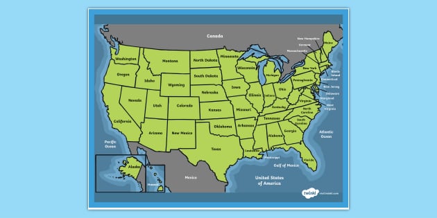
Teach your social studies students all about the geography of the United States with this fantastic map for kids.
 us map
social studies
50 states
states and capitals
united states map
usa
50 states of america
usa map
united states of america
map of america
states of america
america
american states
usa states
states & capitals
3rd-5th
all about the united states
continents
us map
social studies
50 states
states and capitals
united states map
usa
50 states of america
usa map
united states of america
map of america
states of america
america
american states
usa states
states & capitals
3rd-5th
all about the united states
continents
So useful thank you twinkl
great map except Hawaii is not labeled
Hi,It says on the resource that this is a poster, but when it prints, it's only coming out on one piece of A4 paper. Is this a problem my end or is the same for you too? Thanks
Hello SVanstone123,
Thanks for taking the time to get in touch. I have opened the resource and can see that the poster is A4 size. I have asked the design team if they can make this poster over 4 pages of A4.
 lucygi73@Twinkl 5 years ago
Hi there SVanstone123,
We've made this resource for you and it will be ready to download very soon. It will be available from either the 'Other versions' box above, or as a whole new resource. I hope you find it useful!
 Maddison.W1197@Twinkl 5 years ago
Teach your social studies students all about the geography of the United States with this fantastic map for kids.
This detailed map is annotated with the names of each state, as well as the oceans surrounding the United States and the neighbouring countries. It's the perfect way to help children understand the size and location of the states within America, as well as where the US is situated.
Upon downloading this resource, you'll find a handy PDF which is ready to print and use in the classroom. There are lots of ways you can use this United States map for kids. It's designed to support your teaching on the geography of the US, and you could use it in a lesson on American culture, history or climate.
Why not create a spelling test on the names of American states? Children can use this map as a revision tool!
This map of US states is perfect for third and fourth and fifth and sixth geography lessons to expand kids' knowledge on non-European landscapes. Not only will this resource help improve map comprehension, but it introduces kids to landscape a lot larger and diverse than their own.
If your students liked this United States map for kids, we've got plenty more resources for your class to enjoy:
This map of US states resource can be used alongside any of these fantastic US themed resources to expand your kids' knowledge about the world beyond Ireland. Take a closer look at different states and their varying landscapes and climates across the US. Take a moment to think about how they differ to Ireland's landscape and climate. A great idea is to try and find the state that is the closest to Ireland in appearance and climate!
The great thing about this resource is that it is pre-formatted, so all you have to do is press download, and it's ready to go! Brighten up the classroom with this fantastic resource and teach your kids about one of the largest nations in the world.
To look further afield, why not explore this Map of the World with the Equator and Tropics?
Here are some interesting facts about the United States to share with your children. Did you know...
 Home
Home  Membership
  Customer Support
  Create
  Blog
Blog