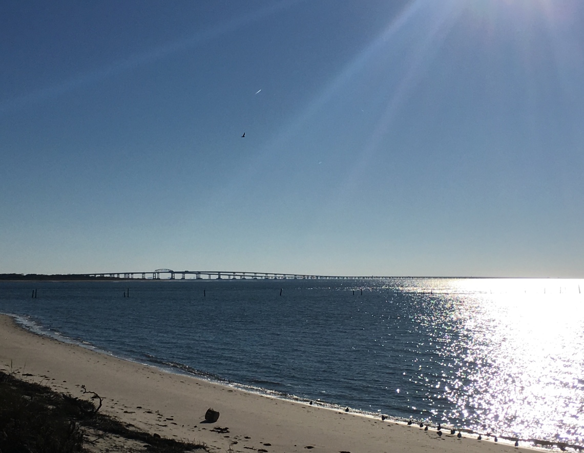
At 3 p.m. I was in the middle of the Chesapeake Bay.
The nearest land was nearly 10 miles distant to the northeast and southwest. The sky was clear of clouds, streaked with pale blues and greens as the sun descended steadily toward the horizon. The icy blue-grey water was around 50-degrees fahrenheit, and at its deepest reached murky depths of 100 feet. I wasn’t adrift or submerged. I was halfway across the Chesapeake Bay Bridge-Tunnel (CBBT), a marvel of modern engineering and a stomach-flipping attraction for intrepid travelers. The 23-mile long feat of infrastructural ingenuity (17.6 miles from shore to shore) may induce an inkling of Thalassophobia in even the most formidable of people.
I approached the CBBT from the north, having driven southbound the entire length of the Delmarva Peninsula (my road trip started in Massachusetts). I had already traversed the newly minted Tappan Zee Bridge up river from New York City, a 3.1-mile twin-span across the widest section of the Hudson. The project cost nearly $4 billion, replacing its unsafe predecessor, which the State of New York described as having produced “twice the average accident rate per mile as the rest of the 570-mile Thruway system.” It’s smoothly paved, solidly built, and is situated higher than its forerunner, allowing for scenic views of the New Jersey Palisades.
From there I hopped on the New Jersey Turnpike which took me to the Delaware Memorial Bridge. This twin suspension bridge is a more imposing figure than the Tappan Zee. It’s shorter but, with both spans reaching heights of 440 feet tall, it towers above the river valley roughly dotted with industrial plants and refineries lit up like cities in the evening.
To avid road trippers like myself, bridges provide more than just a safe crossing over otherwise impassable land or water. They’re stages, and the backdrops are vistas of local history. Both the Tappan Zee and Delaware Memorial Bridges teem with history. Driving over them, quick glances around evoke scenes of Revolution Era warships sailing up and down the channels, old-time ferries shuttling droves from riverbank to riverbank, and innovations in aquatic recreation and arts and culture.
The CBBT dwarfs the Tappan Zee and Delaware in sheer scope, and its history may be even more deeply rooted. An archived article in Geography published in 1965 notes “A link across the mouth of Chesapeake Bay was proposed as early as 1705.”
I paid my dues at the Eastern Shore tollbooth guarding the entrance to the CBBT and veered off to the roadside observation area just before Wise Point, the CBBT’s northern terminus. From here, the CBBT appeared to stretch beyond the choppy tides, horizon, and setting sun, into infinity. I proceeded onward, passing over the narrow Fishermans Inlet between Wise Point and Fisherman Island, a barrier island home to the Fisherman Island National Wildlife Refuge. The CBBT then launched over the open bay.
The highway curved toward the southwest and began a slight incline. The low-grade ascent and steady speed limit made it feel as though I was tiptoeing out into the water. The CBBT leveled out over the North Channel and then declined. It was as modest a decline as it was an incline; but, it seemed to drop right to the water, skimming across the surface, like my car were a stone skipping across a pond. It made this slight descent feel like the initial steep slope of a roller coaster.
Fisherman Island began to disappear in my rearview mirror. To the west were seven freighter ships that, from such a distance, were like toy tugboats floating in a tub. The coastline and horizon to the far-off southeast looked like a hospital heart monitor. The small blips indicated signs of life, like Virginia Beach and Norfolk, and, further east, it flatlined where land meets ocean. The sky had turned the color of a watered down margarita. I turned off my radio and cruised along in serene silence. The solitude was tranquilizing.
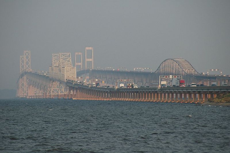
Construction on the bridge began in September 1960 and the CBBT officially opened in April 1964. According to an archived article in Roads & Bridges published in 2001 “construction of the span required undertaking more than 12 miles of low-level trestle, two one-mile tunnels, two bridges, almost two miles of causeway, four man-made islands and 5.5 miles of approach roads.” It cost $200 million. But it only carried passengers northbound. I was driving on a bridge some 30 years its younger. The southbound span, my route, was built between June 1995 and April 1999 for $197 million.
The further out in the bay I went, the more I considered the possibility of catastrophe. After all, I was driving on what appeared little more than a road nestled gingerly atop support piles. Could it withstand the elements? Would it sway and bend when battered by wind and water? Notes the 2002 November/December issue of Civil Engineering, “Because of the potential for violent weather, the structures were designed for 20 ft (6 m) waves and a 10 ft (3 m) storm surge.”
Wind has taken lives on the CBBT. The region’s newspaper, The Virginian-Pilot, wrote in February 2017, “In fact, only 15 vehicles have fallen from the bridge, according to bridge-tunnel spokesman Tom Anderson. Most of those have been tractor-trailers. Only two people have survived the fall, including a trucker who went over the side in January 2016.” At the time this article, about a fatal tractor-trailer crash off the CBBT, was published, the accident constituted “the 79th traffic fatality since the bridge-tunnel complex opened in 1964.” If The Pilot’s article seems to downplay those 15 vehicular falls it’s because most deadly incidents took place before the northbound span opened in 1999, separating “northbound and southbound travelers and reduce head-on collisions. Opposing traffic still passes each other closely in the two tunnels.”
For truckers, though, the wind is a legitimate threat. Their large cargo hauls can catch gusts like rigged sails. If they’re not carrying enough weight during imposed wind restrictions, trucks can easily be blown over. I was fortunate enough to experience an idle air current during my crossing. As I approached the first tunnel, called the Chesapeake Channel tunnel, I could see a bevy of fishing boats around the man-made islands that support both openings of the tunnel. More shipping freighters and military vessels approached the channel to pass over the tunnel below, submerged to depths of 105 feet. From end-to-end, the Channel tunnel is just shy of a mile (5,237 feet). Civil Engineering adds that both tunnels were constructed in piecemeal fashion. “Sections were prefabricated at a Texas plant, then towed by sea to the project site. A screed was used to prepare a trench in the bottom of the bay. The 300 ft (90 m) long tunnel sections, each weighing 2,400 tons (2,180 Mg), were then lowered into the trench and covered with backfill.”
As The Pilot noted, the two bridge spans converge into one at both tunnels, allowing for one lane each for northbound and southbound traffic. The narrowness, plus the depth, can indeed create a claustrophobic feeling. I white-knuckled the entire length of the Channel tunnel, afraid that one mistaken jerk of the wheel or one ill-timed glance around would result in disaster. But the tunnel evened out and began to rise back toward the daylight. I emerged unscathed but found myself immediately passing a roadside graveyard. A length of dead seagulls lined the narrow shoulder of the CBBT. I was unable to find any data or correlations between seagull deaths and the CBBT, but a waterbird monitoring plan put forward the Center for Conservation Biology, College of William & Mary, and Virginia Commonwealth University mentions “larger structures such as the islands of the Chesapeake Bay Bridge Tunnel have been colonized by marine communities and provide habitat for waterbirds.” Where there are communities of life, whether humans or fowl, there is the certainty of death.
Slightly perturbed by the volume of winged corpses, I continued. The coastline ahead was no longer a distant blip. It came increasingly into focus; luxury condos and waterfront property lined the water’s edge. I approached the second CBBT tunnel, the Thimble Shoal Channel Tunnel. Taking a deep breath, I began my descent.
Though I felt a twinge of nervous anxiety driving down through the first tunnel, this time I felt a thrill, revisiting the rollercoaster sensation of when I first took to the CBBT. Down I went and up I came, emerging to find how close I now was to the Virginia shore. Some 20 minutes had passed since I paid the toll back on the peninsula of the Eastern Shore. By now the sky showed dashes of orange and pink as the sun sank lower and lower. To my right I could see sandy beaches coming closer until the CBBT carried me over them to the mainland.
The CBBT is a must-see for road trippers. It puts on full display our engineering capabilities. It instills hope that severely needed infrastructure projects can be willed into existence, even if it takes a number of years. It sheds light on the magnitude of the Chesapeake Bay which, on a map appears to be a decent-sized body of water and in reality is a mammoth estuary, the largest on the continent in fact.
And the CBBT tells a story. An enlightening 2014 article from The Pilot states up front that “Half a century ago, 2,000 workers crossed 17 miles of water with concrete, steel and rock. Seven would die.” Men tirelessly toiled to turn what in the 1950s was an approximately 90-minute ferry into a 20 minute scenic drive. They shed more than 90 miles off the distance it took to travel between Norfolk, Virginia and Wilmington, Delaware. They helped connect two distinct regions of Virginia with one another for the first time. Their legacy, and the legacy of the CBBT itself, is not over.
Construction has already begun on the Parallel Thimble Shoal Tunnel, an endeavor to sink another tunnel into the bay to safely carry two additional lanes of traffic southbound. This will allow for the existing tunnel to carry passengers northbound. Gone will be the fright of facing oncoming traffic in the heart of an underground, underwater, structure. Smooth will be the traffic.
BIO: NICK DELUCA says ” I’m currently employed as a proposal writer for an education services company. My past writing experiences include freelancing for historical magazines and local weeklies; reporting news for an online startup publication in Boston, MA; and handling social media content for the John F. Kennedy Presidential Library.”