Download presentation
Presentation is loading. Please wait.

1
© Copyright 2007

2
The island of Lexill is located just north of Hokkaido, located at 40˚N, 150˚E. The cool ocean currents from the Arctic Ocean flow down near the coastlines of the island. Lexill is shaped like a headless fish. The island is very mountainous, so it snows a lot. In January, the wind patterns, which come from Tasmania, go up and surround Lexill, so the island is about -2˚C during this month. In July, the wind currents that were surrounding the island pass on to Canada, so the island is about 20˚C during this month. Source: http://www.metoffice.gov.uk/weather/asia/japan_past.html

3
Location: 40 ۫N, 150 ۫E Lexill is here!! Source: http://users.hartwick.edu/hartleyc/energy.html

4
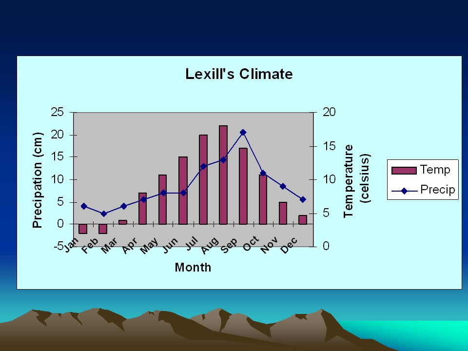
Lexill is to the north of Japan near Hokkaido. It is located 40۫ N, 150۫ E. The island is very hilly, and because it is very hilly and because of its latitude, it snows a lot. The climate of Lexill is humid continental, which fits into coniferous trees. The climate of Lexill’s coastline is really cold because of the ocean currents. The climate of the inland part is also chilly because of snow. Its closeness to the ocean moderates the island’s climate. In the winter, things get very cold, below 4۫C. In the summer, it is short and cool. The temperatures are very low, ranging from 8۫-12۫C. There are a lot of landforms in Lexill- mountains, plateaus, hills, lakes, and streams. Lexill is very mountainous, and the tallest mountain in Lexill is Mount Pana, wher it snows a lot. Because of all the precipitation, these mountains are covered with large, frozen glaciers. The rivers are Black Smith, Velvet, and Persian rivers. The lakes are Red and Ingor Lakes. The island also has the Maxwell and Raymon streams; the island is surrounded by the Pacific Ocean. In the winter, these rivers, lakes, and streams freeze. But in the summer, they thaw and start flowing again. Most of the precipitation is snow, and it occurs most in spring. Source: http://www.metoffice.gov.uk/weather/asia/japan_past.html

6
The sea level is rising around the island, so the scientists of Lexill are concerned about facing problems such as flooding and possible complete submersion in the near future. Many of the inhabitants of Lexill already have left the island, so the number of population is decreasing rapidly. http://www.metoffice.gov.uk/weather/asia/japan_past.html

7
Lexill is too cold to grow many vegetables; it has to mostly trade with other countries. We export bricks, rugs, fish, tasty fungi, and chandeliers to Spain. In return, we import a variety of fruits, vegetables, grains, and some cookies for a nice dessert. Also, we also use big nets with narrow holes to catch fish. Even the tiniest creatures like clams, oysters, and shrimps can’t get out of the holes. The only livestock Lexill has is reindeer. The inhabitants raise these animals so they can eat them and drink their milk for scrumptious meals. http://www.infoplease.com/countries.html

8
Group Members: Hayley Huang Erica Chen Liz King Tatiana Lim Alida Van G. PowerPoint Created By: Hayley Huang © Copyright 2007

Similar presentations