RAGBRAI L Full Route Revealed
- 13 March, 2023
- Anne Lawrie

The full route for the 50th ride across the state of Iowa has been released. There are 30 communities that will host riders as pass thru and meeting towns. This year’s pass thru towns are a mix of small and large communities that have hosted riders successfully over the past fifty years.
DOWNLOAD THE FULL ROUTE MAP
Day 1: Sunday, July 23 Sioux City to Storm Lake
- Theme Day: Mile of Silence & Throwback Jersey Day
- Mileage: 77 miles
- Elevation: 3,504 ft.
PASS THRU TOWNS:
- Kingsley
- WASHTA – MEETING TOWN
- Quimby

Day 2: Monday, July 24 Storm Lake to Carroll
- Theme Day: “I RIDE 4” Day
- Mileage: 62 miles
- Elevation: 1,818 ft.
PASS THRU TOWNS
- Early
- LAKE VIEW – MEETING TOWN
- Breda
- Mt. Carmel

Day 3: Tuesday, July 25 Carroll to Ames
- Theme Day: RAGBRAI Jersey Day
- Mileage: 83 miles
- Elevation: 1,479 ft.
PASS THRU TOWNS
- Glidden
- Jefferson
- RIPPEY – MEETING TOWN
- Luther
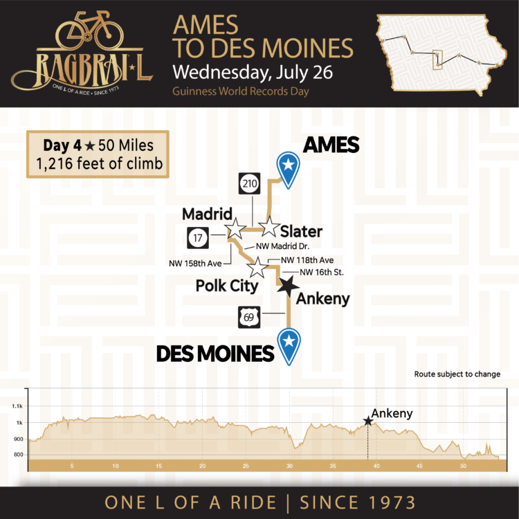
Day 4: Wednesday, July 26 Ames to Des Moines
- Theme Day: Guinness Book of World Records
- Mileage: 50 miles
- Elevation: 1,216 ft.
PASS THRU TOWNS:
- Slater
- Madrid
- Polk City
- ANKENY – MEETING TOWN
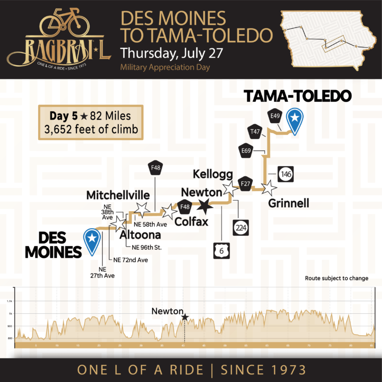
Day 5: Thursday, July 27 Des Moines to Tama-Toledo
- Theme Day: Military Appreciation Day
- Mileage: 82 miles
- Elevation: 3,652 ft.
PASS THRU TOWNS
- Altoona
- Mitchellville
- Colfax
- NEWTON – MEETING TOWN
- Kellogg
- Grinnell
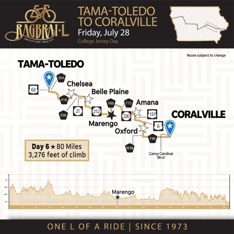
Day 6: Friday, July 28 Tama-Toledo to Coralville
- Theme Day: College Jersey Day
- Mileage: 82 miles
- Elevation: 3,303 ft.
PASS THRU TOWNS
- Chelsea
- Belle Plaine
- MARENGO – MEETING TOWN
- Amana
- Oxford
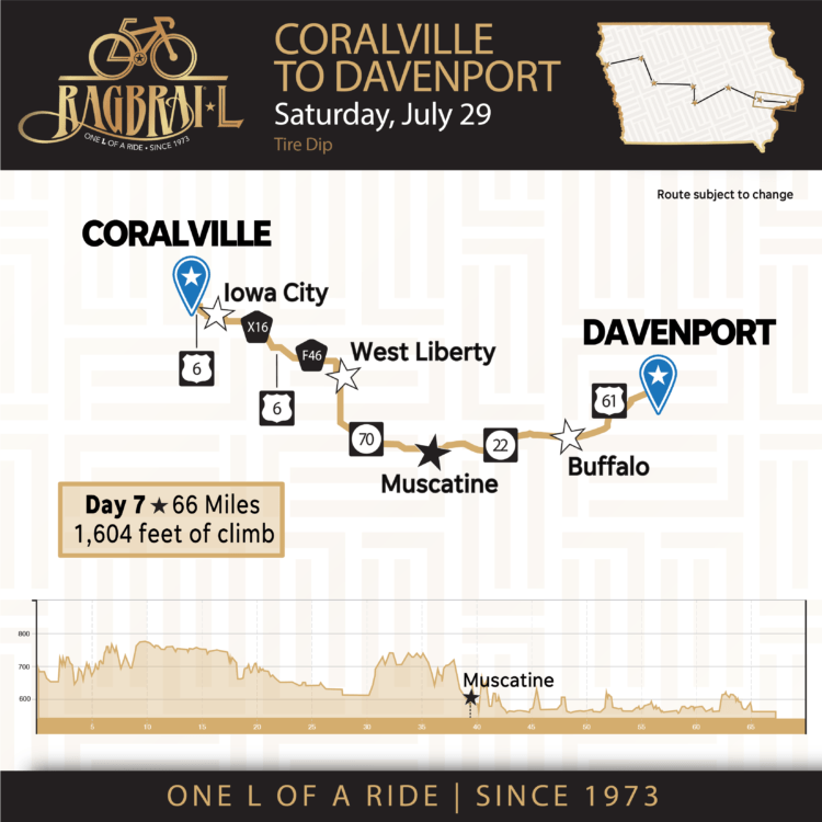
Day 7: Saturday, July 29 Coralville to Davenport
- Theme Day: Tire Dip
- Mileage: 66 miles
- Elevation: 1,604 ft
PASS THRU TOWNS
- Iowa City
- West Liberty
- MUSCATINE – MEETING TOWN
- Buffalo
Read more about the towns and route here.
24 Comments
Submit a Comment
You must be logged in to post a comment.
Related Articles
-
 1 day ago
In this article I am going to review the various equipment you should consider having on you and your bike for RAGBRAI. Bicycle –...
-
 1 week ago
This week on the JustGoBike Podcast! AP and Murph sit down with ride director Matt Phippen to talk about RAGBRAI LI and the full...
-
 2 weeks ago
It’s April and the weather is getting better, and you should be outside now putting in progressively longer rides. To help you...


The map lists US 169 between Ankeny and Des Moines, but it should be US 69.
The county road labels between Iowa City and West Liberty don’t make sense. There is no X16 in Johnson County and F46 is primarily a gravel road in eastern Johnson County and western Cedar County.
I don’t see a Century Loop day.
Century Loop is on Tuesday. The exact route will be released with the Gravel Day later down the road. The map has been updated to reflect the typo and says 69.
In response to the Iowa City and Webster City question. American Legion Road is also X16 and F46 in different spots. Those are accurate but look for American Legion Road in you can’t find the X16 or F46
Did you mean D12 instead of D18 out of Sioux City? D18 does not intersect with 140 according to Google Maps.
What happened to this statement that was originally published??
“Along the way riders will be treated to a generous serving of Iowa hospitality, with 42 pass-through and meet-up towns adding up to a total of 50 communities visited, as compared to 38 on the 2022 ride. It’s a town for every year of the ride.”
Looks great to me. The details will get worked out soon enough.
Let’s ride!
Are you going to post a .gpx or .kml file of the route so us turn by turn bike computer people can preprogram our gps/computer?
In case this hasn’t been submitted, yet, the highway going south out of Tama is 63 not 6.
Maps have been updated and most issues addressed in the comment section have been updated. For the question, about communities. Our routes are subject to change until the day we ride. That could be for any number of reasons. What you are seeing is based on detours we’ve had to take based on road construction or bridge issues since we announced the overnight towns in January. That impact some communities on route. For that reason, we will not publish the gpx or ride files until July to ensure you have the accurate routes.
The Saturday map leaving Iowa City shows X16 (aka American Legion Rd), then US 6, then F46 to West Liberty. This is not accurate.
I look forward to the digital “Ride with GPS” release of the route, so we can see more accurate information.
“Download the Full route here”.
And its a picture. Team Ride GPS, Strava, time to get with the times. Sheesh.
Hi Michelle,
I appreciate your response and recommendation of providing GPS files or some other form of digital file. We will do that in July once the route is official. We still have four months to work with the DOT and ride the route when the weather is nice to ensure the roads we’ve selected in the winter are the right roads in the summer. In the meantime, I hope you can get outisde and ride your bike so you are prepared for this year’s ride.
Good morning, is the finish line/tire dip in Davenport going to be in one of the parks near downtown: Veterans Memorial Park, Centennial Park, Modern Woodmen Park? Here’s a Google Maps link showing the location. Thanks. :)
https://goo.gl/maps/PowhQVaCtVMTC4Pu6
It is going to be great!! Thanks RAGBRAI team for putting it all together. Day 7 route F70 does not go into Muscatine. Assuming you are taking F70-X54-Mulberry all the way downtown and over to 22. Thanks again.
Wednesday is still listed as the Guinness Book of World Records day. I thought that extremely bad idea was cancelled.
I agree. I nominate “Banjo Appreciation Day”. Wednesday, July 26th would be the 70th birthday of the late Michael “Moon” Mullen, the RAGBRAI Banjo Man, who passed away five years ago.
In the past, the RAGBRAI website had very detailed maps for each day, which included the distances between each town. Will those be available again this year?
trying to find the vehicle support route maps
For all of you concerned with the route…Follow the 10,000 bikes in front of you. :)
Will detailed daily maps with distance between towns be available as per previous years?
Need a Charter, any out there? lesgotcha@icloud.com 210-883-8565